- April 17, 2020
- Posted by: BlueSkies
- Categories: Extreme Weather, Forensic Meteorology
Just as every region of the U.S. has its own unique culture and landscape, so too does every region have a unique severe weather profile, or climatology. Some parts of the country are particularly prone to large hail, while others are plagued by rain-wrapped tornadoes, and still others dodge lightning just about every afternoon during the summer.
Below we’ll discuss the four phenomena responsible for most weather-related damage across the U.S. – lightning, severe thunderstorm winds, hail, and tornadoes – and the climatological “hotspots” for each.
Thunderstorms Generally
Florida often claims to be the thunderstorm and lightning capital of the country – and justifiably so, according the meteorological data – but the somewhat ironically named “Sunshine State” isn’t the only region of the United States that’s especially prone to thunderstorms.
According to 25-years of cloud-to-ground lightning strike data from the National Lightning Detection Network, the bull’s-eye for the most lightning strikes and the most thunderstorm days per year is indeed found in southern Florida, where on average, storms rumble across the sky on more than 110 days per year (that’s almost one in every three days!). However, an arc of 70+ thunderstorm days per year extends across the entire northern and eastern Gulf Coast from Houston, TX through all of Florida. In these regions rimming the warm and moist Gulf of Mexico, thunderstorms can be expected to occur nearby on at least one out of every 5 days per year.
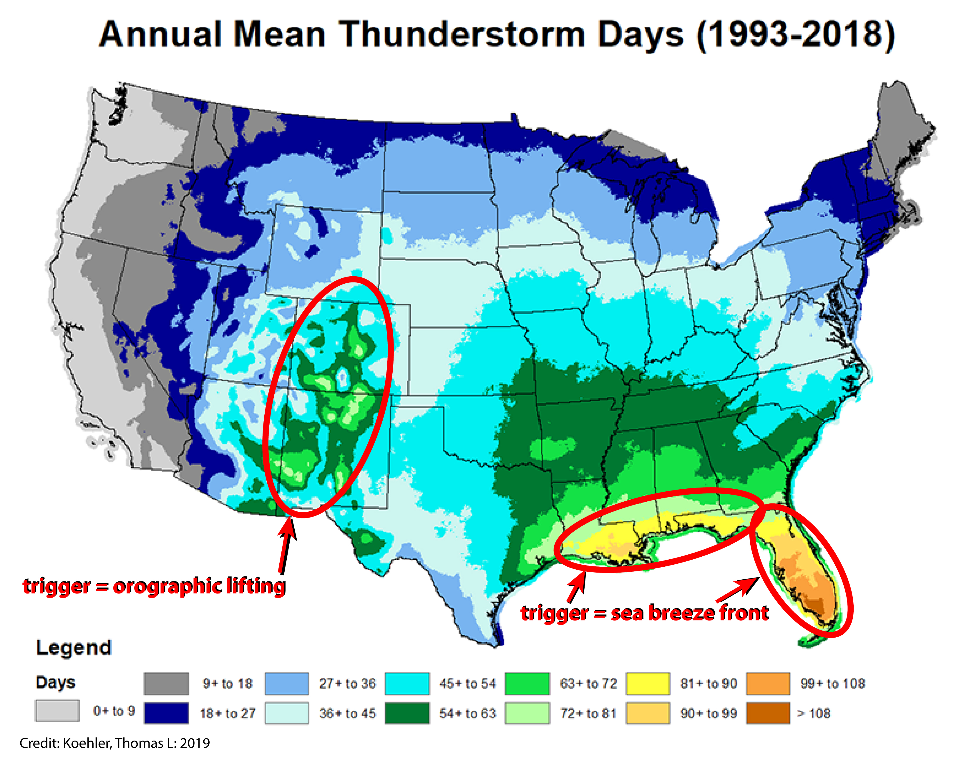
A perhaps somewhat less expected stormy region is found in the southeastern Rocky Mountains, where 55 – 80 thunderstorm days per year are typical near the highest elevations (although this probably isn’t too surprising to anyone who’s spent a few summer days hiking in Colorado or New Mexico and watched the clear blue morning skies turn gray and growling by mid-afternoon).
All thunderstorms require three ingredients to develop:
1) moisture
2) an unstable atmosphere
3) a triggering/lifting mechanism
For both of these thunderstorm maxima (and indeed for most of the United States), the primary source of moisture is warm, moist air blowing in from the Gulf of Mexico. From spring through early fall, prevailing southerly winds advect warm, humid air from the Gulf into the southeastern two-thirds of the country. Those steamy summer evenings you spend sitting on the porch sipping a cool beverage and listening to a chorus of crickets as lightning flashes in the distance? That’s likely courtesy of the Gulf of Mexico.
Atmospheric instability is also fairly seasonal, with unstable conditions – an atmosphere that cools quickly with height – most common during spring, summer, and early fall.
However, the thunderstorm triggering mechanism is quite different in the mountains versus along the coast. Anything that forces warm, moist air near the surface to rise into cooler air aloft can act as a thunderstorm trigger.
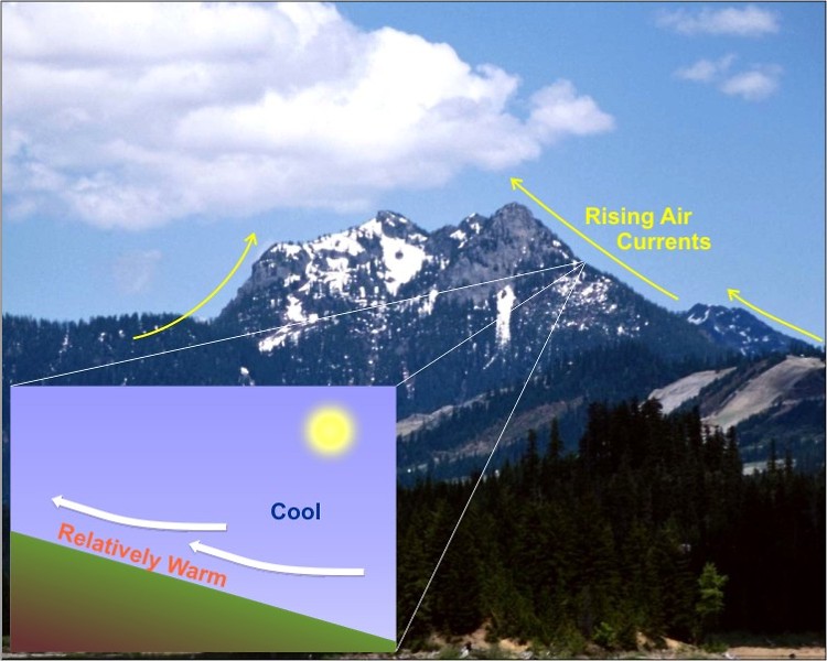
In the mountains, this trigger is the interplay between the strong high-altitude sunshine that heats the side of the mountain and the mountain itself. As the air near the surface of the mountain warms, it expands and becomes less dense, causing it to rise and follow the slope of the mountain toward the summit. In weak prevailing winds, this upslope flow occurs on both sides of the mountain, and when these flows collide at the summit, they have nowhere to go but straight up, forming a nascent thunderstorm updraft.
In the southeastern Rockies, these upslope flows often tap into the moist air that pools in the Great Plains as a result of southerly winds off the Gulf of Mexico. The Gulf provides the moisture, a relatively steep atmospheric lapse rate provides the instability, and the high-altitude sun heating up the mountainside provides the trigger.

In Florida and along the immediate Gulf Coast, the trigger is a direct result of the proximity of the ocean: the sea breeze. Sea breezes form because land heats up (and cools down) more quickly than water. On a sunny day, the land warms quickly and heats the air directly above the surface. This warming air expands and rises, and as it does so, it is replaced by cooler, denser air from over the ocean. This boundary between warm, unstable air inland and the cool, stable air moving in from the water acts like a shallow cold front that follows the contours of the coast.
During the day, as the temperature difference between the land and the sea increases (the land continues to warm, but the water remains at nearly the same temperature), the sea breeze strengthens and advances inland. Along the sea breeze, warm humid air is forced to rise by the advancing wedge of cooler ocean air that hugs the surface. If the atmosphere is even marginally unstable (and it usually is during the summer in the coastal South), this buoyant warm, humid air will trigger thunderstorms along the sea breeze.
In Florida, sea breezes often form along both the east and west coasts and march inland as the day progresses. By afternoon, they meet near the middle of the state and the squeeze-play between the two sea breezes causes an expansion and intensification of thunderstorms along the spine of the peninsula. The result? Florida is the repeat winner of the “stormiest state” prize.
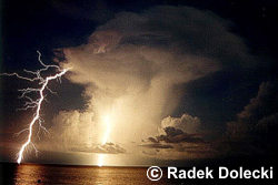
Lightning
Unlike most of the other thunderstorm hazards that present a risk to life and property, a storm does not have to be severe to produce damaging lightning. Any storm worthy of the name produces lightning. But not all lightning is equally damaging.
A lightning strike is often composed of more than one (sometimes dozens) of individual strokes. Each stroke carries a different amount of current. About 90% – 95% of lightning strikes are “negative flashes” that initiate from the negatively-charged lower- and mid-levels of the storm. These flashes typically strike the ground near the parent storm, although not always.
That leaves the 5% – 10% of lightning strikes that are “positive flashes”. These originate in the positively-charged upper levels of the storm. Because these strikes arc from the top of the storm, ionizing tens of thousands of feet of air, they must pack a very potent electric punch, with a peak current and electric potential up to ten times greater than negative flashes. Because many positive strikes originate near the edge of a thunderstorm cloud or from the anvil, they also tend to strike the ground farther away from the parent storm – sometimes as much as 20 miles from the precipitation. These are the so-called “bolts from the blue” that strike from apparently clear sky (in fact, they strike from a nearby thunderstorm, but the sky immediately above the impact point could be free of clouds).
Lightning strikes can be composed of several strokes that give the lightning a flickering appearance, or they can be more damaging “continuing current” strokes in which charge flows continuously over a longer period of time through the lightning channel. Because electricity flows over a longer period of time during continuing current flashes, more heat builds up. For that reason, continuing current flashes are more likely to cause structural fires.
However, any lighting strike can fry electronic equipment, and it doesn’t have to strike a structure directly to cause this type of damage – lightning can be conducted through electrical wires, telephone lines, data cables, and even wet ground.
Damaging Winds
Although Florida, the Gulf Coast, and the southeastern Rockies take the prize for highest frequency of thunderstorms, strong winds (greater than 58 mph) and wind damage are more common farther north, across the southern Appalachian Mountains. Another maximum is centered over eastern Oklahoma and extends into southern Kansas and far western Arkansas.
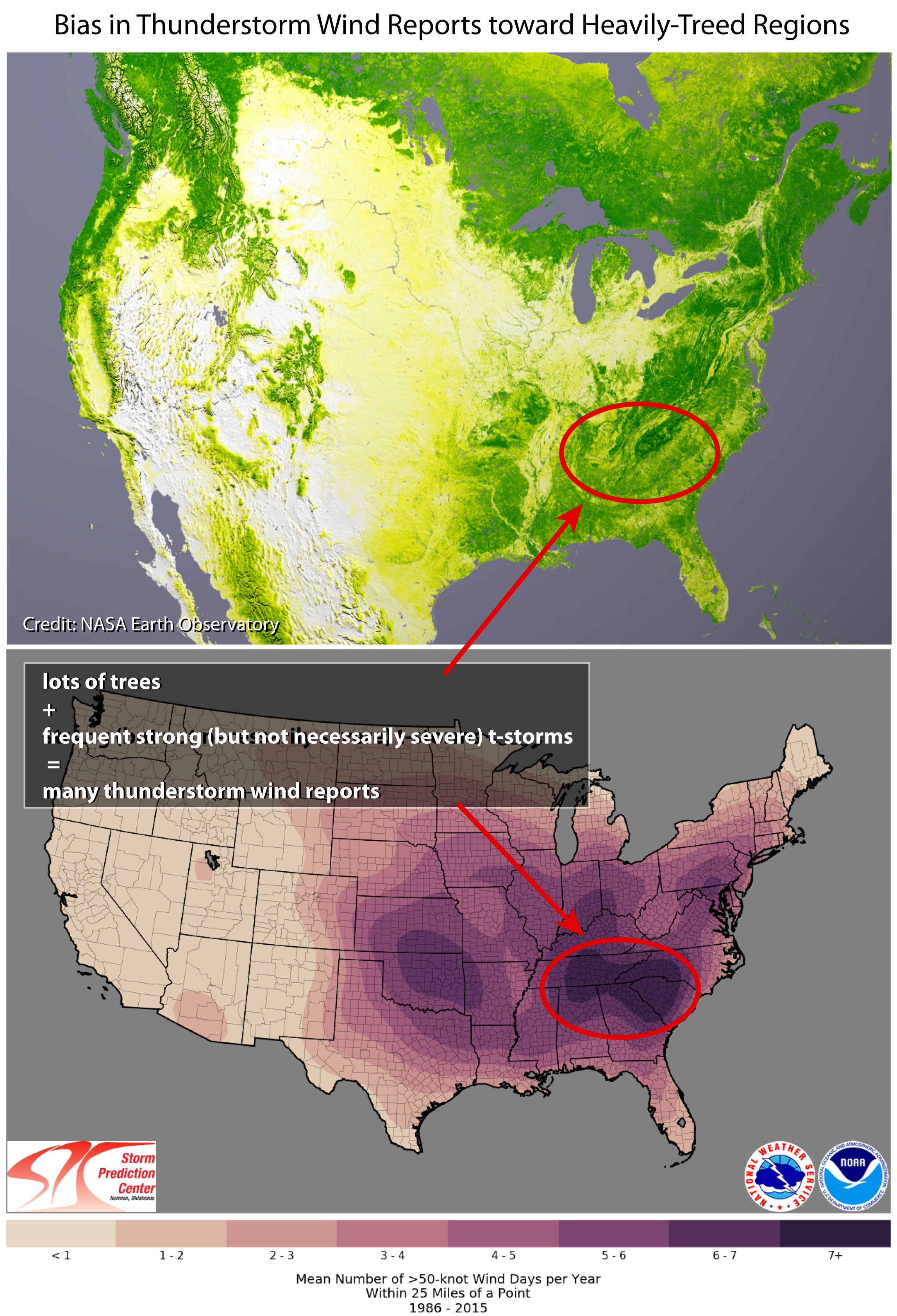
The bull’s-eye in the southeastern US is not a purely meteorological signal, though, because in order for an event to be recorded as a severe “thunderstorm wind,” a wind gusts over 58 mph must be measured or – and this is the important part – wind-related damage must be reported. Marginally severe winds (under 65 mph or so) tend not to cause significant damage to structures, but they can and do cause significant damage to trees. So we’d expect to find more thunderstorm wind damage in those areas more vulnerable to it – i.e. in areas with plenty of trees that can be broken or toppled by low-end severe (or even sub-severe) winds.
And where do we find a lot of trees? In the southeastern US, but not so much in the Great Plains. When fallen trees or tree branches block roads, take down power lines, fall on cars, or land on roofs, they tend to get reported and end up in the weather data as “thunderstorm wind” events. For that reason, there is a bias in the wind data toward heavily-treed regions, like the southeastern US.
We can see this bias by looking only at very strong wind gusts (greater than 64 kts or 74 mph) that do cause damage to structures or by looking only at measured wind gusts (as opposed to wind damage reports). By either of these measures, the bull’s-eye in the southeast is far less prominent that the relatively low-tree region centered in the southern Great Plains, which is far more prone to the type of weather that produces extreme winds: supercell thunderstorms and severe, organized convection like squall lines.
Hail
Large hail is responsible for billions of dollars of property damage each year – to roofs, siding, HVAC units, vehicles, and crops.
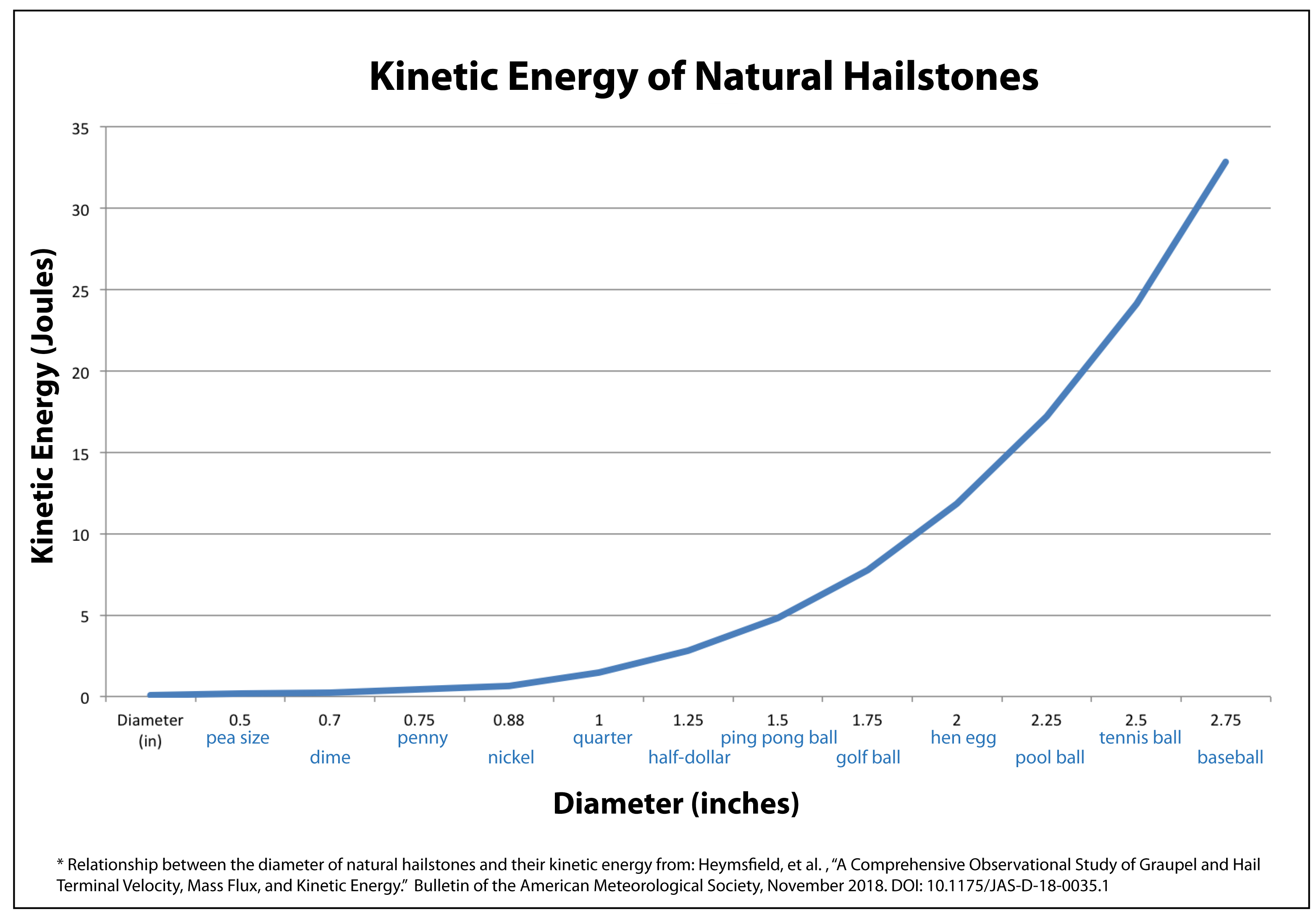
Sub-severe hail (i.e. hail up to 1” diameter) generally does not cause substantial property damage, although it can damage crops and sensitive vegetation. Structural damage begins to occur to shingle and some tile roofing materials at hail sizes of 1” – 1.5” diameter, with the age and condition of the roof contributing to the degree of observed damage. Denting of car metal generally starts with hail around the size of golf balls (1.75” diameter).
As the size of a hailstone increases, so too does its terminal velocity and kinetic energy. It is the rapid transfer of this kinetic energy from the hailstone to the surface it strikes that causes damage, and the kinetic energy of hailstones has been shown to increase exponentially with an increase in their diameters. Strong winds also increase the damage caused by hailstones by imparting an additional horizontal velocity to the hailstones, thereby increasing their kinetic energy. Wind-blown hail is also more likely to strike and damage vertical surface (like the exterior walls of buildings), whereas hail that falls in lighter winds tends to concentrate damage on horizontal surfaces (like roofs).
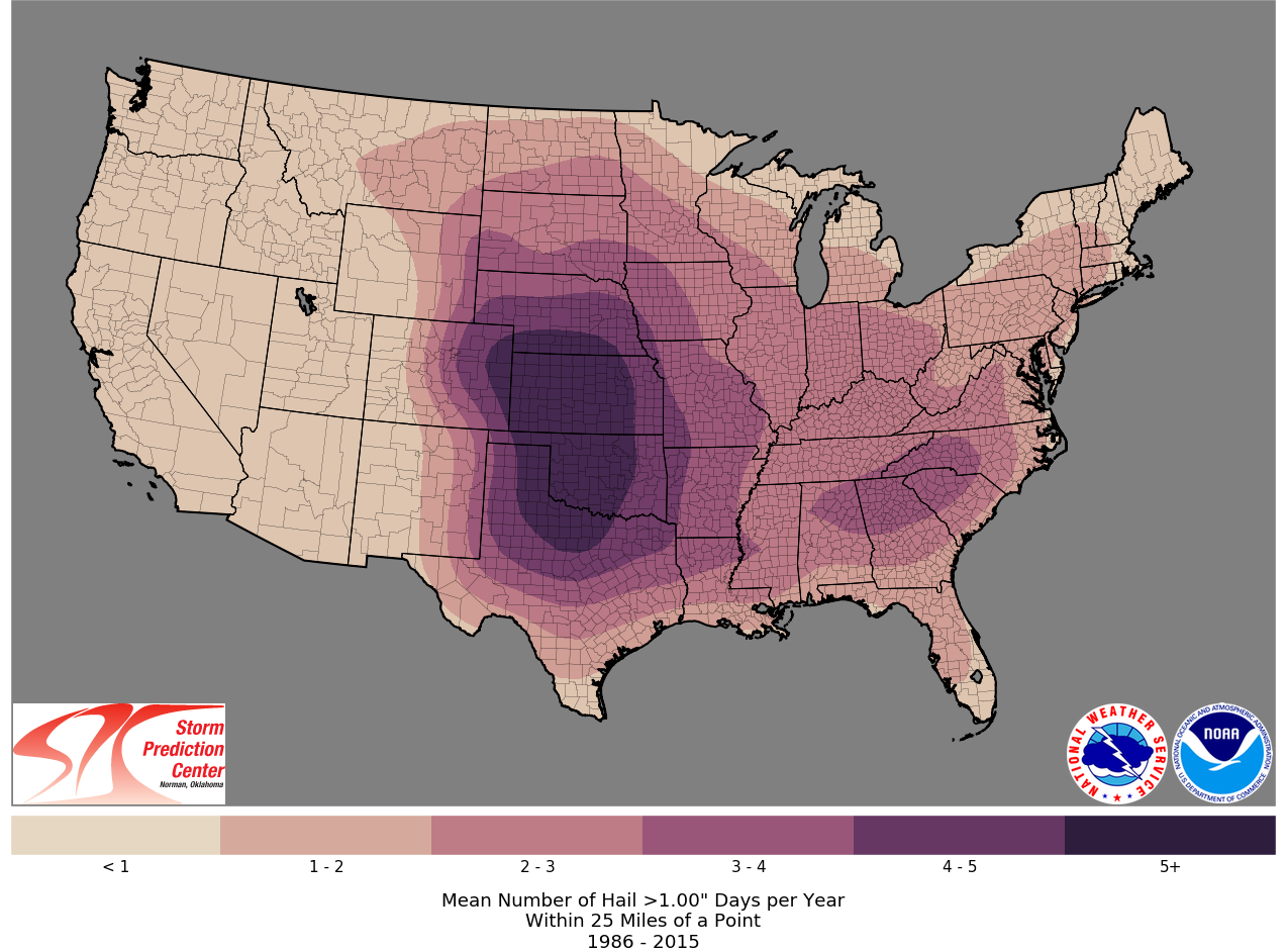
So where is severe hail (1” diameter or larger) most likely? Unsurprisingly, right in the heart of the Great Plains – from northern Texas, stretching through most of Oklahoma and Kansas, and including western Colorado and southern Nebraska.
In this region of the country, the ingredients for large hail come together like clockwork every spring: a highly unstable atmosphere that encourages explosive thunderstorm updrafts capable of growing and suspending large hailstones, strong vertical wind shear that separates updrafts from downdrafts (rain within downdrafts causes hail to melt more quickly), and reasonably low freezing levels that maximize the depth of the hail growth zone aloft and minimize the amount of time the hail falls through above-freezing temperatures on its way to the ground.

Take note that there’s not much overlap between the hotspots for thunderstorm frequency (Florida and the northern Gulf Coast) and the hotspots for severe hail (the southern and central Great Plains). In other words, the places most prone to thunderstorms are not the places most prone to severe hail.
The reason for this quickly becomes apparent when you consider that thunderstorm season along the Gulf Coast is the summer, and the summer in this part of the country feels very much like living in a sauna for four months. The heat and humidity near the surface typically extends for miles into the atmosphere, with relatively light winds. The freezing level is high and wind shear is minimal: in other words, saunas are not very hospitable environments for balls of ice.
Tornadoes
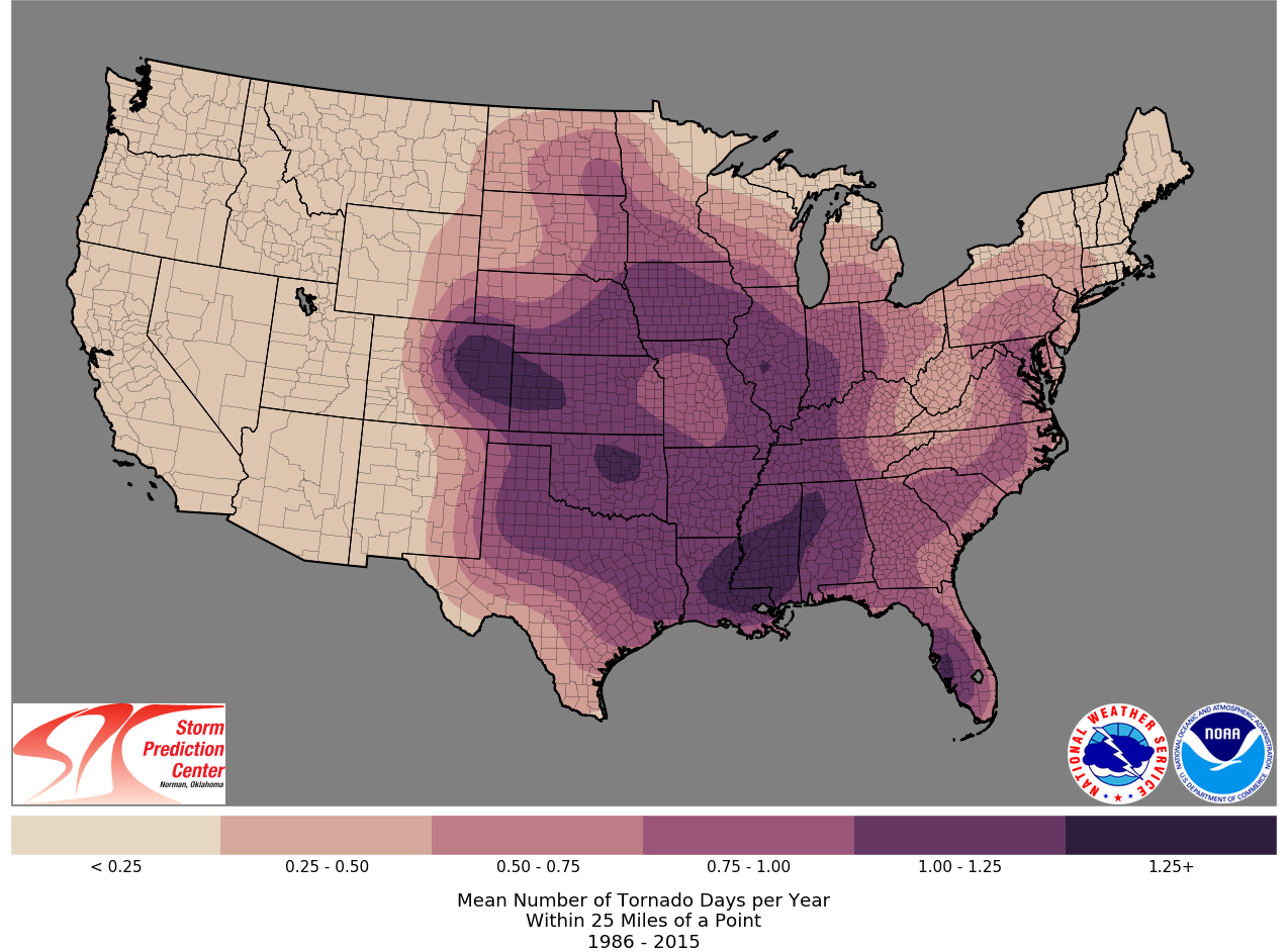
Although we may think of Tornado Alley as centered on Oklahoma and Kansas (i.e. “those places destroyed in the movie Twister”), tornadoes are a regular yearly occurrence across the central third of the country, including the Great Plains, Midwest, and Southeast. Two prominent hotspots are traditional Tornado Alley centered on Oklahoma and “Dixie Alley” that encompasses Mississippi, Alabama, and Tennessee.
The southern Great Plains are most active during the Spring (late March through May), with tornado activity shifting toward the northern Plains and Midwest as summer progresses. As the rest of the country begins to cool toward fall and winter, Dixie Alley takes over as the tornado hotspot (SPC monthly tornado probability maps).
The seasonality of tornado alley and the meteorology behind its roaming nature is discussed in a previous Blue Skies article.
Summary
Although severe weather can, and does, occur in just about every state in the nation, there are distinct hotspots for different thunderstorm hazards.
With towering thunderstorms bubbling up many, if not most, afternoons during the late spring through early fall, the northern Gulf Coast and all of Florida are especially prone to lightning-related hazards, as are the southeastern Rocky Mountains out west.
Wind-related damage tends to concentrate in the southern Appalachian Mountains, where dense tree-cover provides ample opportunity for even marginally severe winds to cause widespread damage. The strongest thunderstorm winds, however, are founds out in the southern Great Plains, in the heart of traditional Tornado Alley.
The southern Great Plains are also home to the largest hail and most frequent severe hailstorms due to the potent combination of warm, moist air from the Gulf of Mexico mixing with dry air coming over the Rocky Mountains, ample vertical wind shear, and relatively low freezing levels. However, severe hail (hail 1” diameter or greater), can be found annually across much of the U.S., from Montana to New Hampshire, from Texas to Florida, and just about everywhere in between.
Tornadoes likewise regularly impact the central and eastern half of the country, although strong and violent tornadoes (those rated EF2 or higher on the Enhanced Fujita scale tend to concentrate in the Great Plains and the Deep South.
As we roll into spring and early summer, remember that while some regions of the country are climatologically more prone to certain types of damaging weather, severe weather truly knows no boundaries of season or place. Stay alert, and reach out to Blue Skies for a forensic meteorological analysis if you have questions about the location, magnitude, or timing of a damaging weather event in your area.