- March 7, 2015
- Posted by: BlueSkies
- Categories: Extreme Weather, Forensic Meteorology
Weather radar works by emitting microwave radiation into the sky and then listening for the signal that’s reflected back. It’s a meteorological game of Marco Polo.
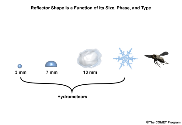
All sorts of targets reflect the microwaves – raindrops, snowflakes, hailstones, bats, airplanes, and even swarms of insects. How well a given target reflects microwaves depends on its composition, size, and shape. For instance, liquid water is a better reflector of radar energy than ice.
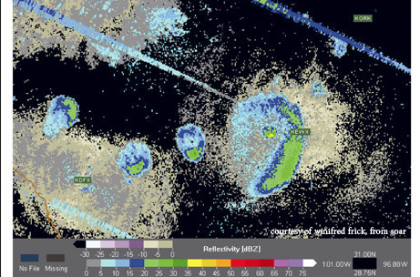
When a meteorologist looks at a radar display, she’s seeing the reflected signal from all those targets in a given slice of sky. The radar doesn’t “know” which piece of reflected energy came from a bird and which piece came from the hailstone that moments later cracked your car windshield. The radar simply aggregates the reflected signal. It’s up to the meteorologist to interpret the results.
Until just a few years ago, the National Weather Service’s network of weather radars collected information about only two quantities: the reflected energy from a given section of sky (reflectivity) and the velocity of the targets within that section (mean radial velocity and spectrum width). In complex meteorological situations like winter weather events or severe storms, these two pieces of information provide only an incomplete picture of the type of precipitation that’s falling. When you’re just looking at reflectivity and velocity data, for instance, it can be difficult to tell the difference between hail and heavy rain. Yet on the ground, knowing the difference can be critical.
Enter dual-polarization radar technology. If you’ve ever owned polarized sunglasses, you’re already familiar with the principle of polarization. The short-n-sweet version is that electromagnetic waves (like radio waves emitted by radar or visible light waves emitted by the sun) can be oriented along a certain axis.
Tilt your head from side to side while wearing polarized sunglasses, and you’ll notice that the image you see changes – the color of the sky darkens and lightens, glare off the pavement appears and disappears. As you tilt your head, you’re actually changing the polarization of the light that’s being let through your sunglasses, and that gives you additional information about the world around you.
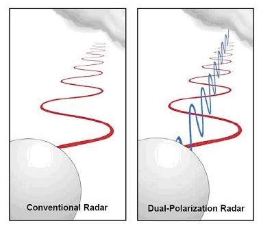
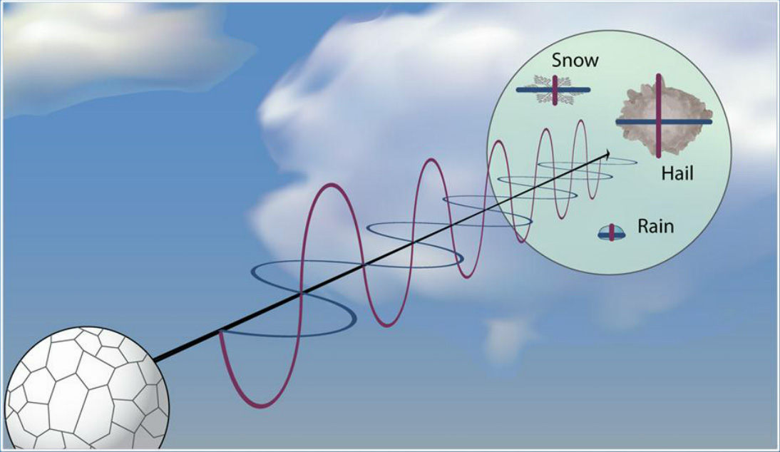
The same is true with weather radar. Conventional radar sends out radio pulses polarized only in the horizontal direction, so the reflected signal carries only 1-dimensional information. Dual-polarization (or “dual-pol”) radar, on the other hand, sends out both horizontally polarized pulses and vertically polarized pulses, so the reflected signal carries 2-dimensional data.
This may seem rather trivial until you consider that precipitation types have characteristic shapes. Small raindrops are spherical, while big raindrops flatten out like a Frisbee. Hailstones are roughly spherical when they’re dry but can become oblong as their outer layers melt. The two-dimensional data provides invaluable insight into what types of precipitation are present within a storm.
Here in Florida, we don’t have to worry too much about winter weather, but hail is another matter. In the lightning capital of the United States, thunderstorms are part of the scenery for much of the year, and most thunderstorms, if they are strong enough and reach high enough into the atmosphere, produce hail.
But that hail doesn’t always reach the ground. In warm, moist atmospheres, hail melts as it falls toward the ground. If the hail starts out small or if the freezing level is high in the atmosphere, hail can melt completely before reaching the ground. Dual-pol radar data can reveal whether a storm is producing hail aloft, and by examining radar data at different heights within the storm, meteorologists can determine whether and how much that hail is melting before it reaches the surface (and people’s cars and houses).
Dual-pol radar adds three more tools to the meteorologist’s kit. Each of these tools provides unique information about the size, shape, and mixture of precipitation types within a storm.
Correlation Coefficient (CC)
Correlation coefficient measures how similarly the returned horizontal and vertical pulses are behaving. It’s like looking at the world under a strobe light. From one flash to the next, how much does the image change? When the targets within a given region are of the same shape and type (for example, all medium-sized raindrops), one pulse will look much like the next, and the correlation coefficient will be high. If, on the other hand, precipitation types are mixed (like rain and hail swirling together), correlation coefficient values will be lower. Generally, the larger the hail, the lower the correlation coefficient.
Differential Reflectivity (ZDR)
Differential reflectivity compares the reflectivity values returned in the horizontal and vertical directions, like comparing how much the image through your polarized sunglasses changes as you tilt your head. Targets that are wider than they are tall (like large raindrops) have higher differential reflectivity – they reflect more horizontally polarized energy than vertically polarized energy. Hailstones, on the other hand, are more spherical and tend to tumble as they fall, reflecting roughly equal amounts of horizontally and vertically polarized energy. Hail typically has low to near-zero ZDR values.
Specific Differential Phase (KDP)
Specific differential phase is a bit more complicated than correlation coefficient and differential reflectivity. Physically, KDP measures the phase shift of the returned horizontal and vertical signals. In practice, this means that specific differential phase responds to both the shape and the density of liquid water targets. Frozen precipitation, like dry hail and snow, do not contribute to KDP – KDP “ignores” frozen precipitation and sees only liquid precipitation. Specific differential phase is therefore useful for determining rainfall rate.

As part of the dual-polarization upgrade, National Weather Service weather radars now incorporate an algorithm that estimates precipitation type from the dual-pol variables discussed above. Numerous automated hail report websites use the National Weather Service algorithm or a custom one to identify regions of hail. While such algorithms provide a useful first-pass to identify regions within a storm where hail is likely being produced aloft, they do not provide information about whether that hail is reaching the ground and at what size.
When Blue Skies Meteorological Services investigates the presence of hail for a forensic meteorology case, we don’t just run an algorithm and depend on the radar to “know” what was happening in the storm and to assume what was happening on the ground. We examine official storm reports, severe weather warnings and advisories, the atmospheric profile, and dual-polarization radar data at multiple heights and throughout the lifetime of the storm to reconstruct a comprehensive picture of the weather situation – both high in the storm and on the ground, where it matters.