- June 2, 2014
- Posted by: BlueSkies
- Categories: Communication and Education, Extreme Weather, Hazard Mitigation
3150 days, give or take a few. That’s how long it’s been since a major hurricane, defined as a Category 3 or higher storm, has made landfall in the U.S. The previous record was about 2250 days, almost 2.5 years shorter. Although the time between major hurricane landfalls has varied significantly since 1900, it’s been about 500 days (or every 1-2 years) on average.
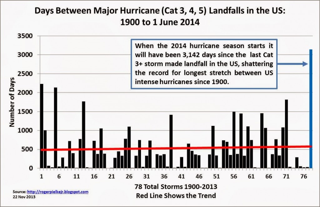
So, are we really due?
It’s hard not to think so. After all, if we flip a coin 8 times (for the last 8 years in which the US escaped a strike by a major hurricane) and all 8 come up heads, we start thinking, “It’s bound to come up tails next time.” But we’d be wrong (well, unless the coin was rigged). Statistics just don’t work that way. Each coin flip has the exact same 50/50 probability of heads/tails, regardless of the pattern of results that came before. So the fact that we did not suffer a major hurricane landfall last year or the year before does not in any way influence the probability of a landfall this year.
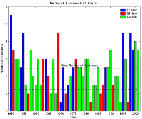
What does influence the probability of a landfall is the number of storms that form and the atmospheric steering flow that guides those storms toward or away from the US coastline. This year, an El Niño pattern is expected to form during the summer or early fall, bringing warmer waters to the eastern equatorial Pacific Ocean, and, among other things, stronger vertical wind shear, stronger trade winds, and greater atmospheric stability to the Carribean and tropical Atlantic Ocean. Strong vertical wind shear inhibits tropical cyclone development, as it tends to rip nascent storms apart before they have the opportunity to organize and develop, and enhanced atmospheric stability does just what it sounds like – stabilizes the atmosphere and hinders storm formation. For these reasons, moderate to strong El Niño years are often associated with below-average hurricane activity in the Atlantic basin.
In addition to the predicted development of El Niño later this year, Atlantic sea surface temperatures (SSTs) in the main tropical cyclone development region are expected to remain slightly below average throughout the June 1 – November 30 hurricane season. Tropical storm systems draw their energy from the warm waters over which they develop – cooler water means less energy and, generally, fewer and less intense storms.
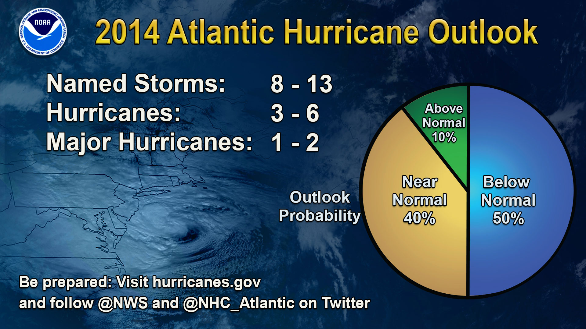
These two major factors – the expected development of El Niño and cooler sea surface temperatures in the tropical Atlantic – have led most hurricane forecasters, including NOAA, to predict an average to below-average hurricane season for 2014.
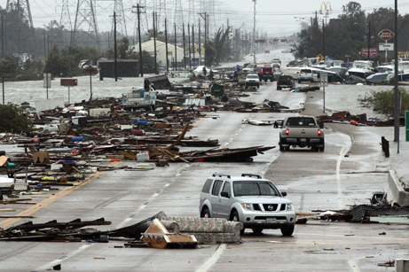
Given the lack of a major hurricane landfall in the US during the last 8 years and the below average 2014 Atlantic hurricane season forecast, the most dangerous part of this year’s hurricane season may be complacency. We would do well to remember that it only takes one storm to create devastation (like Hurricane Andrew in 1992 that struck during an otherwise quiet season) and that even non-major hurricanes can bring widespread destruction (Hurricane Ike in 2008 and Sandy in 2012 come immediately to mind).
Both Ike and Sandy go to show that the sustained wind speed of a tropical cyclone (and therefore its Saffir-Simpson category) does not solely determine its destructive potential. The physical size of the storm is also a critical determinant of its storm surge, and water kills far more people and destroys far more property than wind.
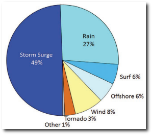
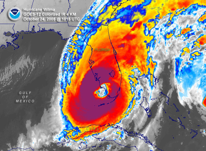
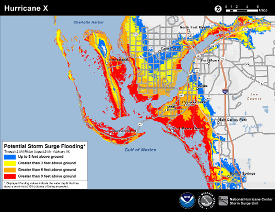
The danger that storm surge poses to life and property is often poorly understood outside of the meteorological community (despite the well-publicized tragedy and horror brought by Hurricane Katrina’s storm surge in 2005). To address this common knowledge gap, the National Weather Service will begin issuing experimental Potential Storm Surge Flooding Maps for the U.S. East Coast and Gulf Coast during the 2014 hurricane season. For each hurricane that is forecast to make landfall, the storm surge maps will show the geographical areas where storm surge could occur as well as how high above ground level the water could reach in those areas. The maps are intended to provide a reasonable estimate of the worst case scenario for flooding in those areas that could be impacted by an approaching storm.
Last week’s National Hurricane Preparedness Week, highlighted the many dangers associated with tropical cyclones, including storm surge, inland flooding, and wind. These hazards, especially inland flooding, wind, and severe thunderstorms, can affect locations hundreds of miles from the coast, so hurricane preparedness isn’t just for those folks lucky enough to live where most of us only vacation. Chances are, even if you don’t live near the coast, you have friends or family who do. Both the National Hurricane Center and Ready.gov offer excellent resources related to understanding and preparing for tropical cyclones.
Many coastal states, including Florida, Louisiana, and Virginia, offer sales tax holidays when you purchase hurricane preparedness supplies at the start of the hurricane season. For those of you in Florida, like us here at Blue Skies, that sales tax holiday runs through this upcoming Sunday, June 8.
We’re hoping for a season as quiet as the forecast, but even so, we’re gathering our storm supplies and reviewing our plan. We hope you’re doing the same!