- February 18, 2014
- Posted by: BlueSkies
- Categories: Climate, Extreme Weather, Forecasting, Hazard Mitigation
After several relatively quiet years in the equatorial Pacific Ocean, El Niño may be on its way back.
A new research study published in the Proceedings of the National Academy of Sciences (PNAS, February 2014) utilized a novel, long-range statistical approach to El Niño forecasting and found a 75% likelihood that El Niño conditions will begin to present by the end of 2014.
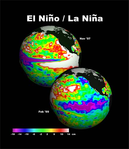
El Niño is the warm phase of a larger ocean-atmosphere cycle called the El Niño Southern Oscillation (ENSO). During an El Niño event, the waters of the eastern equatorial Pacific off the coast of Central and South America become anomalously warm. During the opposite phase of the cycle, La Niña, those same waters become anomalously cold (see figure at right, credit: NASA).
This fluctuation in water temperature may seem like a relatively localized phenomenon, but because the ocean and atmosphere are coupled (interconnected) and circulate the entire globe, an increase in water temperatures off the coast of Peru is not only devastating to the local fishing industry, but is also the most important driver of natural interannual climate variability across the entire planet.
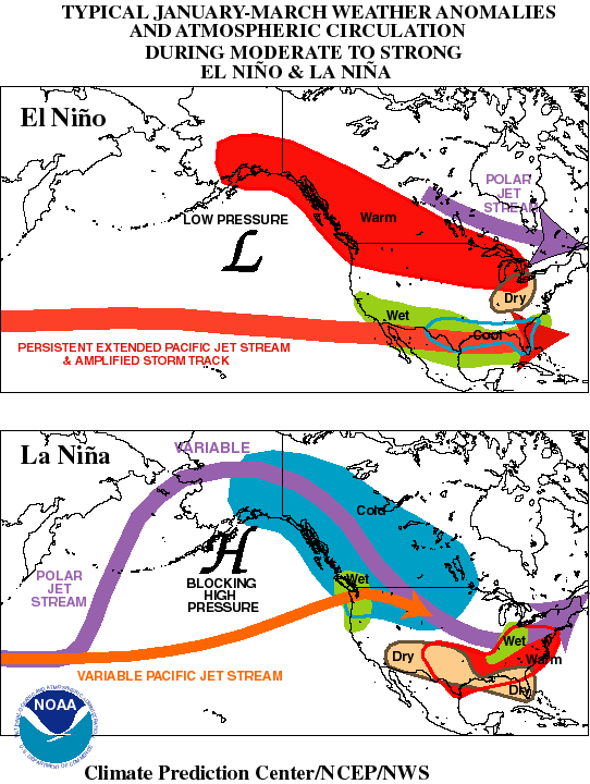
Globally, El Niño conditions result in a major shift in atmospheric circulations and, consequently, weather patterns (see figure below right, credit: NOAA), as well as an increase in globally averaged temperatures.
In the northern hemisphere, El Niño conditions typically result in
- Stronger, more frequent storms affecting the southern US, especially during winter, due to a more vigorous and more southerly subtropical jet stream
- Warmer than normal temperatures throughout the northern US, southern and western Canada, and Alaska
- Drier upper Midwest in the US
Conventional El Niño forecasting techniques rely on dynamical and statistical climate models that analyze observations of sea surface temperatures (SSTs) and wind patterns. Although this forecast method can be quite accurate when making predictions a few months out, its skill is rather limited at longer-range forecasting. Accurate long-range forecasting is critical, however, to preparing for and mitigating the economic effects of El Niño events. For example, in the agricultural sector, farmers need to be able to plan which crops to plant based on expected weather conditions (e.g. hotter than normal, wetter than normal, drier than normal, etc) to reduce the likelihood of crop failure.
The study published by Ludescher, et al. this month claims to have developed a forecasting technique that can accurately predict ENSO fluctuations up to a year in advance by relying solely on statistical correlations between air temperatures across the Pacific region and upcoming changes to equatorial Pacific SSTs (i.e. upcoming El Niño or La Niña events). Although the study’s authors tout its long-range predictive ability, it cannot currently predict the magnitude (severity) of those upcoming events.
The study’s authors say that their technique accurately predicted the absence of El Niño during 2012 and 2013, but because the forecasting methodology is so new, it has yet to be tested in a prediction of non-neutral ENSO conditions. Many atmospheric scientists not involved with the study remain skeptical of the skill of the new technique for that reason as well as for the fact that the study does not propose an explanation as to why the statistical correlation should work. In other words, the study does not advance scientists’ understanding of the physical mechanisms that drive the ENSO cycle.
If the new statistical forecasting technique proves successful, though, it may alleviate a problem that has been plaguing conventional ENSO forecasters for the last couple of years and that may now be negatively affecting the skill of seasonal climate (e.g. ENSO) forecasts.
The National Oceanic and Atmospheric Administration (NOAA) maintains a network of moored buoys in the tropical Pacific Ocean to monitor real-time ocean temperatures for input into the climate models used to forecast El Niño and La Niña. Since budget cuts in 2012 forced NOAA to reduce its maintenance schedule of the buoys, however, over half of them have failed. With less detail about ocean temperatures in this critical location being provided by the thinning buoy network, forecast models may suffer a loss of accuracy.
Only time will tell. The dynamical and statistical climate models used to provide conventional ENSO forecasts are also beginning to predict an increased likelihood of El Niño conditions beginning in late 2014. It’s still too early for significant confidence, but those readers who are involved in weather-sensitive industries should monitor the situation closely and consider planning early for possible El Niño conditions beginning in late fall 2014.


